
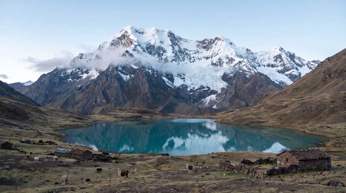
Ausangate Trail: Route Data & Elevation Profile

Sacred Mountain Circuit at Extreme Altitude

Scroll
  1. Expert Difficulty
  2. 80km Total Distance
  3. 5,130m Max Elevation
  4. 6days Duration

May to September (dry season only – closed October through April)

Best Season

Interactive Trail Map

Trail Route

Trail Information

Essential Stats

Distance

80 km

Duration

6 Days

Difficulty

Expert

Max Elevation

5,130 m

Trail Details

Trail Status

Seasonal

Starting Coordinates

-13.7878, -71.2489

Best Season

May to September (dry season only – closed October through April)

Andean Survey · Altitude Data

Elevation Profile

5,130 m
Peak
+1,280 m
Gain
9
Points
Ausangate Trail: Route Data & Elevation Profile – Elevation Profile Trail waypoints: Tinki Village Trailhead at 3,850 m, Upis Valley Camp 1 at 4,300 m, Arapa Pass at 4,850 m, Pucacocha (Red Lake) Camp 2 at 4,650 m, Palomani Pass at 5,130 m, Ausangatecocha Camp 3 at 4,600 m, Qampa Pass at 5,051 m, Pacchanta Hot Springs Camp 4 at 4,250 m, Rainbow Mountain (Vinicunca) at 5,050 m 3,658 4,213 4,767 5,322 ELEVATION (M) 1 2 3 4 5 5,130 m 6 7 8 9
STN 01
Tinki Village Trailhead
3,850 m
Start
STN 02
Upis Valley Camp 1
4,300 m
STN 03
Arapa Pass
4,850 m
STN 04
Pucacocha (Red Lake) Camp 2
4,650 m
STN 05
Palomani Pass
5,130 m
Peak
STN 06
Ausangatecocha Camp 3
4,600 m
STN 07
Qampa Pass
5,051 m
STN 08
Pacchanta Hot Springs Camp 4
4,250 m
STN 09
Rainbow Mountain (Vinicunca)
5,050 m
End

The Ausangate Circuit represents Peru’s most demanding multi-day trek, circumnavigating the sacred Ausangate Mountain (6,372 meters) through extreme high-altitude terrain. This 6-day route crosses five mountain passes exceeding 5,000 meters elevation, traversing remote Andean wilderness where traditional herding communities maintain centuries-old lifestyles amid stunning turquoise lakes and rainbow-striped geological formations.

For essential planning information about trekking in the Cusco region and connecting routes, explore our comprehensive Cusco travel guide covering acclimatization strategies, seasonal considerations, and regional trek comparisons.

Route Overview and Daily Challenges

The trek begins at Tinki village (3,850 meters) with a 4-hour drive from Cusco. Day one covers 12 kilometers ascending through Upis valley to first camp at 4,300 meters, introducing the extreme altitudes that characterize this route. The trail passes traditional alpaca herding communities maintaining Quechua traditions largely unchanged since Inca times.

Day two conquers Arapa Pass at 4,850 meters, the first of five major passes. The 14-kilometer section descends to camp at Pucacocha (Red Lake) at 4,650 meters, where mineral-rich waters create distinctive crimson coloration. Nights at this elevation test altitude tolerance with oxygen levels at approximately 55 percent of sea level.

Day three presents the trek’s most demanding challenge: Palomani Pass at 5,130 meters, the circuit’s highest point. This 13-kilometer section requires crossing permanent snowfields and navigating loose scree before descending to Ausangatecocha camp at 4,600 meters, positioned directly below Ausangate’s massive south face glacier.

Day four crosses two consecutive passes – Qampa at 5,051 meters and Jampa at 5,050 meters – covering 15 demanding kilometers to camp at Pacchanta hot springs (4,250 meters). The natural thermal pools provide welcome relief for exhausted muscles after three days above 4,500 meters.

Day five includes the circuit’s cultural highlight: visiting Rainbow Mountain (Vinicunca) at 5,050 meters via Warmisaya Pass (4,980 meters). The 16-kilometer route showcases the famous multi-colored mineral deposits creating natural rainbow striping across the mountainside before descending to camp at 4,400 meters.

Day six completes the circuit with 10 kilometers descending to Tinki for vehicle return to Cusco, typically arriving late afternoon.

Extreme Altitude Considerations

The Ausangate Circuit maintains the highest sustained elevation of any major Peruvian trek. The entire route operates above 4,300 meters with five passes exceeding 5,000 meters – conditions equivalent to Everest Base Camp. This creates extreme altitude sickness risk requiring exceptional acclimatization preparation.

Spend minimum 4 to 5 days acclimatizing in Cusco before attempting this trek. Consider preliminary acclimatization treks like Rainbow Mountain day hike (5,200 meters) or Lares Trek (4,600 meters maximum) to test altitude tolerance. Even properly acclimatized trekkers experience symptoms including severe headaches, nausea, insomnia, and extreme fatigue at these elevations.

Medical screening before booking is essential. Individuals with heart conditions, high blood pressure, respiratory issues, or previous severe altitude sickness should avoid this trek. Reputable operators require health questionnaires and may request medical clearance for trekkers over 60 years old.

Physical Demands and Preparation

This expert-level trek demands exceptional physical fitness and previous high-altitude trekking experience. Daily hiking ranges from 6 to 9 hours over extremely challenging terrain including permanent snowfields, loose scree slopes, stream crossings, and sustained steep climbs at extreme altitude where every step requires effort.

Train intensively for 12 to 16 weeks before departure. Focus on cardiovascular endurance (ability to sustain effort for 8+ hours), leg strength for climbing with heavy breathing, and previous experience trekking above 4,000 meters. Practice hikes with elevation gain exceeding 1,000 meters prepare leg muscles and mental resilience.

Previous experience on demanding multi-day treks is essential. This is not a first trek to Peru – complete lower-elevation routes first to understand your altitude tolerance and multi-day trekking capabilities before attempting Ausangate.

Best Season and Weather

May through September dry season provides the only reasonable trekking window. June, July, and August offer most stable weather with minimal precipitation, though nighttime temperatures regularly drop to -15 degrees Celsius. Even during dry season, afternoon snow showers occur frequently above 5,000 meters.

Avoid October through April when heavy snowfall makes high passes dangerous or impassable. Wet season brings whiteout conditions, avalanche risk, and stream crossings that become impassable after storms. Most operators cease Ausangate departures November through March due to safety concerns.

Weather changes extremely rapidly at this elevation. Prepare for sun, wind, rain, snow, and freezing temperatures within single day. Morning may bring clear blue skies while afternoon storms create near-zero visibility within minutes. Pack comprehensive weather protection regardless of forecast.

Remote Location and Support

The circuit traverses extremely remote territory far from roads, towns, or medical facilities. Cell phone coverage is non-existent. Evacuation requires porter-assisted descent for several hours minimum before vehicle access. Helicopter evacuation is theoretically possible but logistically complex at these elevations with weather constraints.

Independent trekking is possible but not recommended. The combination of extreme altitude, remote location, challenging navigation, and medical risk makes guided support strongly advisable. Reputable operators provide experienced guides familiar with high-altitude medical emergencies, satellite communication equipment, comprehensive first aid, emergency oxygen, and porter support for medical evacuations if required.

Tour packages include all camping equipment rated for extreme cold, porters and pack animals to carry gear and establish camps, specialized high-altitude meals maintaining energy at elevation, and guides trained in high-altitude emergency response.

Cultural Encounters

The circuit passes through territory of traditional alpaca and llama herding communities maintaining Quechua language and customs. These families live year-round at elevations exceeding 4,500 meters in stone corrals with their herds, following patterns established for centuries.

Ausangate Mountain holds deep spiritual significance in Andean cosmology as an Apu (mountain deity) protecting Cusco region. Annual Qoyllur Rit’i pilgrimage brings thousands of devotees to Ausangate’s glaciers in June, one of Peru’s largest indigenous religious celebrations. Trekkers witness this living cultural tradition in landscapes considered sacred.

Essential Specialized Equipment

Extreme altitude and cold require specialized gear beyond standard trekking equipment. Essential items include sleeping bag rated to -20 degrees Celsius (sleeping above 4,500 meters every night creates severe cold exposure), expedition-weight down jacket, waterproof/breathable shell layers, warm gloves and liner gloves, balaclava for face protection, high-quality waterproof boots with excellent ankle support, and trekking poles essential for stability on scree and snow.

High-altitude considerations require water bottle insulation (water freezes overnight in tents), hand warmers for extreme cold mornings, high-energy foods (appetite suppresses at altitude), electrolyte supplements for hydration, and comprehensive sun protection including glacier glasses rated UV400 and SPF 50+ sunscreen as snow reflection intensifies exposure.

Related Tours and Alternative Treks

For those seeking Cusco region trekking without extreme altitude demands, consider the Classic Inca Trail reaching 4,215 meters maximum, or the Salkantay Trek with better altitude profile and warmer camping elevations. The Choquequirao trek emphasizes archaeological exploration over extreme altitude.

Trail Information

Getting There
Access
From Cusco: Operators provide 6:00 AM pickup for 4-hour drive (120 km) via Ocongate to Tinki village. Route passes through Urcos, Ccatcca, and Ocongate. Paved to Ocongate, unpaved final 30 minutes to Tinki. Independent option: Bus from Cusco to Ocongate (3.5 hours, 15-20 soles), then taxi to Tinki (30 minutes, 20-30 soles). Trek is circular returning to Tinki for vehicle pickup back to Cusco. Road conditions deteriorate significantly in rainy season – may require 4×4. Return journey typically late afternoon day six arriving Cusco evening.
Parking
Limited parking at Tinki village trailhead. Informal attendants watch vehicles for tips (20-30 soles for 6 days). Most trekkers use operator-arranged transportation. If driving personal vehicle, confirm parking security with local families. Trek is circular route returning to same point. High clearance vehicle recommended for final unpaved section, especially in wet conditions.
Nearest Town
Tinki village (3,850 m) – trek starting/ending point with basic supplies and simple restaurants. No hotels. Ocongate (3,550 m) 30 minutes from Tinki offers basic hostels. Cusco (120 km, 4 hours) provides all services and only reliable medical facilities. IMPORTANT: No towns, facilities, or road access anywhere along 6-day circuit route. Complete remoteness for entire trek. Emergency evacuation requires porter-assisted descent for hours before vehicle access. Cusco Hospital Regional (+51 84 223691) is nearest facility for serious medical issues.
Permits & Fees
Permits Required
No special permits required for the circuit itself. Small entrance fee (10 soles) collected at Tinki by local community. No daily limits or advance bookings needed. Guides strongly recommended but not legally mandatory. Most operators include all fees in package pricing.
Trail Fees
Trek packages range from 550-850 USD including guide, porters/pack animals, all camping equipment, meals, entrance fees, and transport from Cusco. Budget options 550-650 USD use basic camping. Premium tours 750-850 USD provide upgraded equipment, smaller groups, and better meals. Costs include 5 nights camping, all meals, professional guide, emergency oxygen, satellite communication, and round-trip Cusco transport. Not included: sleeping bags (rental 30-40 USD for -20°C rating), tips for staff (70-100 USD), travel insurance, personal gear.
On the Trail
Equipment
EXTREME COLD GEAR ESSENTIAL: Sleeping bag rated -20°C minimum (rental 30-40 USD expedition grade), expedition down jacket rated to -15°C, waterproof/breathable shell jacket and pants (Gore-Tex), warm base layers (merino wool), insulated mid-layers, down jacket for camp, heavy winter gloves plus liner gloves, balaclava for face protection, warm beanie, neck gaiter, high-quality waterproof boots with excellent ankle support, gaiters for snow, trekking poles (essential for scree/snow), glacier sunglasses UV400, sunscreen SPF 50+, headlamp with lithium batteries (alkaline fail in cold), 4L water capacity with insulated containers, water bottle insulation, hand/toe warmers, high-energy foods. TECHNICAL: GPS device, satellite messenger (if independent), altitude medication prescribed by doctor, comprehensive first aid kit, emergency bivy sack. PROVIDED: 4-season tents, thick sleeping mats, dining tent, tables, cooking equipment, meals. This is expedition camping – standard trekking gear insufficient.
Best Season
May to September (dry season only – closed October through April)
Camping
All 5 nights at extreme altitude camps above 4,250 m. Night 1: Upis Valley (4,300 m). Night 2: Pucacocha/Red Lake (4,650 m). Night 3: Ausangatecocha below main glacier (4,600 m). Night 4: Pacchanta hot springs (4,250 m). Night 5: Post-Rainbow Mountain camp (4,400 m). No facilities except basic stone corrals used by herders. Temperatures drop to -15°C to -20°C overnight requiring expedition-grade equipment. Tour operators provide 4-season tents, thick sleeping mats, dining tents, and heated water. Personal sleeping bags rated -20°C essential (standard -10°C bags insufficient). Pack animals transport camping equipment. Pacchanta offers natural hot springs for bathing.
Safety
Safety Tips
CRITICAL: Monitor altitude symptoms constantly. Inform guide immediately of severe headaches, vomiting, confusion, or breathing difficulty. Ascend slowly despite thin air making every step difficult. Hydrate 4-5 liters daily even when not thirsty – dehydration accelerates altitude sickness. Eat frequently despite suppressed appetite – energy depletion dangerous. Start each day very early (5:00 AM) to cross passes before afternoon weather. Weather changes in minutes – keep rain gear and warm layers accessible. Never separate from group in this remote terrain. Respect sacred sites and herding communities. Stream crossings can be treacherous – follow guide instructions. Apply sunscreen hourly – snow reflection creates severe burn risk. Use glacier glasses above 5,000 m. Bring personal first aid kit with altitude medication, blister treatment, pain relievers. Download offline maps but rely on guide expertise. Keep passport copy separate from original.
Altitude Warning
EXTREME ALTITUDE DANGER: Entire trek above 4,300 m with five passes exceeding 5,000 m. Highest sustained elevation of any Peruvian trek. Oxygen levels 55% of sea level or less. MANDATORY acclimatization: Spend 4-5 days in Cusco before attempting. Consider preliminary high-altitude day hikes. Altitude sickness symptoms universal even for acclimatized trekkers – expect severe headaches, nausea, insomnia, extreme fatigue, shortness of breath. Medical screening required – NOT suitable for those with heart conditions, high blood pressure, respiratory issues, or previous severe altitude sickness. Guides carry emergency oxygen and pulse oximeters. Immediate descent is only treatment for severe symptoms. Helicopter evacuation complex at these elevations. Travel insurance with high-altitude coverage to 6,000 m mandatory. This is expert-level altitude exposure – do NOT attempt as first high-altitude trek.
Water Sources
Abundant streams and lakes throughout route but ALL water requires purification. Lakes are glacial melt (safe after purification). Streams cross all valleys. Operators provide boiled water at camps. Carry 3-4 liters personal capacity as dehydration increases altitude sickness. Refill at each camp. Water bottles freeze overnight – store in sleeping bag or use insulated containers. Purification tablets, filters, or UV treatment essential. High-altitude dehydration is severe – drink constantly despite reduced thirst reflex.
Navigation
Trail Signage
Minimal trail marking. Ancient herding paths through high-altitude terrain. Navigation challenging in fog, snow, or whiteout conditions common above 5,000 m. Cairns mark some sections but inconsistent. Social trails created by livestock complicate navigation. GPS essential but guide expertise critical – multiple route variations exist. Cloud cover and snow obscure landmarks. Guide knowledge of pass locations, safe camping areas, and water sources essential. Independent navigation requires expert mountaineering experience, GPS proficiency, and contingency planning. 98% of trekkers use guides for safety and navigation.
Guide Requirement
Guides not legally required but STRONGLY recommended approaching mandatory for safety. Expert-level trek in remote high-altitude terrain with serious medical risks, challenging navigation, extreme weather, and zero rescue infrastructure. Guides provide altitude emergency management, satellite communication, route finding in poor visibility, campsite knowledge, cultural mediation with herding communities, and emergency evacuation coordination. Independent trekking requires: extensive high-altitude mountaineering experience (5,000+ m), wilderness navigation skills, satellite communication device, comprehensive emergency medical training, cold-weather camping expertise, and Spanish fluency. Medical risks and remoteness make guided support prudent even for experienced mountaineers.
Cell Coverage
Zero cellular coverage for entire 6-day circuit. Complete communication blackout from Tinki departure to return. Guides with reputable operators carry satellite phones for emergencies only. No Wi-Fi, no phone signal, no communication. Inform family of blackout period. Emergency coordination relies on guide’s satellite equipment and porter runners to road access points. This remoteness is why independent trekking is dangerous – no ability to call for help. Download all offline maps, GPS tracks before departure.

Emergency Information

Know before you go – important emergency contacts

Tourist Police Cusco (DIRTURE) +51 84 221961 24/7 emergency coordination. WhatsApp: +51 980 122335 for emergencies when returning to coverage.
National Police Emergency 105 Peru national emergency line. No coverage on trail – use after return to Tinki or Cusco.
Medical Emergency (SAMU) 106 National ambulance. Cusco Hospital Regional: +51 84 223691. Clinica Pardo: +51 84 240387 (English staff, high-altitude expertise)
Mountain Rescue Cusco +51 984 621369 High-altitude rescue coordination. Contact through tour operator's satellite communication from trail.

Frequently Asked Questions

Only experienced trekkers with previous high-altitude experience above 4,500 meters should attempt Ausangate. You need excellent physical fitness, ability to hike 6-9 hours daily in thin air, previous multi-day trekking experience, and proven altitude tolerance. Medical clearance essential for anyone over 60 or with pre-existing conditions. NOT suitable for first-time Peru trekkers, those without altitude experience, or anyone with heart/respiratory issues. Complete easier high-altitude treks first (Inca Trail, Salkantay) to test your tolerance before attempting this expert-level circuit. Most successful trekkers have mountaineering backgrounds or extensive high-altitude trekking experience.

Ausangate is Peru’s most challenging and potentially dangerous trek due to sustained extreme altitude (entire route above 4,300 m with five passes over 5,000 m). Altitude sickness risk is severe even for acclimatized trekkers. Remote location means evacuation requires hours of porter-assisted descent before vehicle access. Weather can change from clear to life-threatening snowstorm within minutes. No cell coverage for emergency calls. However, with proper acclimatization (4-5 days in Cusco), guided support with emergency oxygen and satellite communication, appropriate gear for extreme cold, and conservative pacing, thousands complete successfully each year. The danger comes from inadequate preparation or pushing through severe altitude symptoms.

Spend 4-5 days minimum acclimatizing in Cusco (3,400 m) before starting. Include acclimatization day hikes to Rainbow Mountain (5,200 m), Humantay Lake (4,200 m), or other high-altitude sites. Consider doing a preliminary multi-day trek like Lares (4,600 m max) or Salkantay (4,630 m) one week before Ausangate to test altitude tolerance. Consult doctor about Diamox (acetazolamide) for prevention. Train intensively for 12-16 weeks focusing on cardiovascular endurance and leg strength. Practice hikes with 1,000+ meter elevation gain. Arrive Peru 7-10 days before trek allowing comprehensive acclimatization. Hydrate aggressively (4-5 liters daily), avoid alcohol, eat high-carb diet. Even perfect preparation doesn’t guarantee success – some people simply cannot tolerate elevations above 5,000 m.

Legally yes, practically no for 98% of trekkers. Independent trekking requires expert mountaineering skills including high-altitude navigation, wilderness survival, emergency medical training, satellite communication equipment, comprehensive gear for extreme cold camping, and proven experience above 5,000 meters. The combination of extreme altitude, remote location, challenging navigation in whiteout conditions, and serious medical risks makes guides strongly advisable. Guides provide altitude emergency management, satellite phones, route finding, cultural mediation, camping logistics, and evacuation coordination. Most independent attempts are by experienced mountaineers with expedition backgrounds. First-time Ausangate trekkers should use guided tours for safety – packages (550-850 USD) provide equipment, support, and emergency response worth the investment.

May through September dry season only. June, July, and August provide most stable weather though afternoon snow showers common even in peak season. Avoid October through April completely when heavy snowfall makes passes dangerous or impassable, whiteout conditions create navigation hazards, and avalanche risk becomes severe. Most operators stop Ausangate departures November through March due to safety concerns. Even in dry season, weather changes rapidly from clear to snowstorm within minutes. There is no ‘guaranteed safe’ weather period – proper gear and guided support essential whenever you attempt. Early season (May) has more snow but fewer crowds. Late season (September) offers dryer conditions approaching rainy season transition.

Immediate descent is the only treatment for severe altitude sickness. Guides monitor all trekkers with pulse oximeters and symptom checks. If you develop severe symptoms (persistent vomiting, confusion, difficulty breathing, inability to walk straight), guides coordinate emergency descent using porters to assist walking or carry if necessary. Descent requires 2-4 hours to reach elevation providing relief, then vehicle evacuation to Cusco medical facilities. This is why satellite communication and guided support are critical – no cell coverage for emergency calls. Helicopter evacuation is possible but logistically complex at 5,000+ meters with weather constraints. Travel insurance with high-altitude coverage to 6,000 m and emergency evacuation is mandatory. Prevention through proper acclimatization and conservative pacing is far better than treatment.