
Choquequirao Trail: Route Data & Elevation Profile

Remote Sister City of Machu Picchu

Scroll
  1. Hard Difficulty
  2. 64km Total Distance
  3. 3,050m Max Elevation
  4. 5days Duration

May to September (dry season with stable trail conditions)

Best Season

Interactive Trail Map

Trail Route

Trail Information

Essential Stats

Distance

64 km

Duration

5 Days

Difficulty

Hard

Max Elevation

3,050 m

Trail Details

Trail Status

Open

Starting Coordinates

-13.5367, -72.8956

Best Season

May to September (dry season with stable trail conditions)

Andean Survey · Altitude Data

Elevation Profile

3,050 m
Peak
+200 m
Gain
6
Points
Choquequirao Trail: Route Data & Elevation Profile – Elevation Profile Trail waypoints: Capuliyoc Trailhead and Viewpoint at 2,850 m, Apurimac River Suspension Bridge at 1,550 m, Chikisca Campsite at 1,830 m, Marampata Ridge Camp at 2,910 m, Choquequirao Archaeological Site at 3,050 m, Llama Terraces Sector at 2,950 m 1,325 1,975 2,625 3,275 ELEVATION (M) 1 2 3 4 5 3,050 m 6
STN 01
Capuliyoc Trailhead and Viewpoint
2,850 m
Start
STN 02
Apurimac River Suspension Bridge
1,550 m
STN 03
Chikisca Campsite
1,830 m
STN 04
Marampata Ridge Camp
2,910 m
STN 05
Choquequirao Archaeological Site
3,050 m
Peak
STN 06
Llama Terraces Sector
2,950 m
End

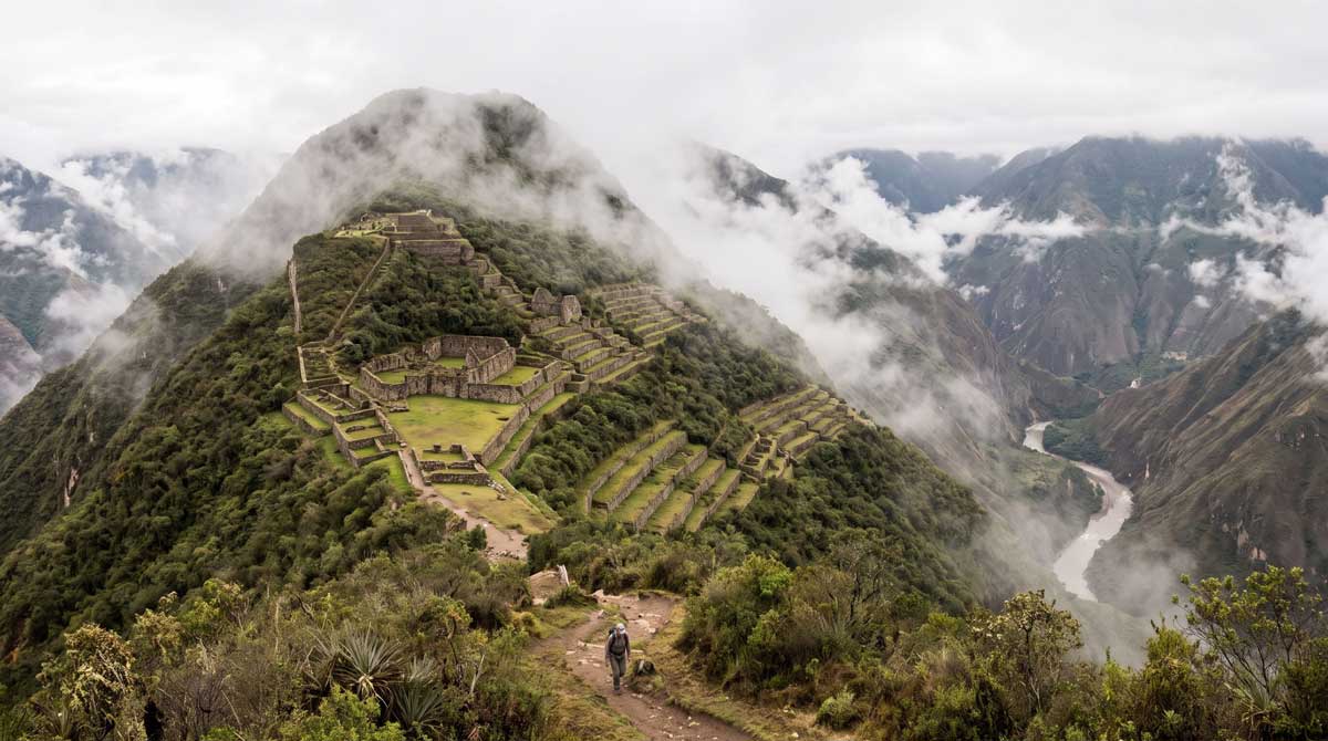
The Choquequirao Trek delivers one of Peru’s most demanding and rewarding archaeological adventures, descending 1,500 meters into the Apurimac Canyon before climbing back up to reach the spectacular Choquequirao ruins at 3,050 meters. This 5-day, 64-kilometer journey visits a site three times larger than Machu Picchu yet receiving only 30 visitors daily, offering genuine discovery in remote wilderness.

For comprehensive planning resources about trekking in the Cusco region and connecting archaeological sites, visit our detailed Cusco travel guide covering acclimatization, seasonal considerations, and regional trek comparisons.

Route Overview and Daily Breakdown

Day one begins with a 4-hour drive from Cusco to Capuliyoc viewpoint at 2,850 meters. The trek immediately plunges 1,500 meters down switchbacks to the Apurimac River at 1,550 meters, crossing via suspension bridge. The brutal descent tests knees and quads over 8 to 9 hours before climbing 280 meters to Chikisca camp at 1,830 meters for the night.

Day two conquers the trek’s most punishing section: ascending 1,220 meters over 14 kilometers from Chikisca to Marampata camp at 2,910 meters. This relentless climb through exposed terrain in intense sun typically requires 7 to 8 hours of sustained effort. Marampata sits on the ridge overlooking Choquequirao ruins visible across the valley.

Day three provides relief from extreme elevation changes with a gentle 2-hour, 140-meter ascent to Choquequirao archaeological site at 3,050 meters. Spend 4 to 5 hours exploring the extensive terraces, ceremonial platforms, residential zones, and the remarkable llama terraces featuring intricate stone llama figures. The site sprawls across multiple levels with restoration ongoing, revealing new structures annually.

Day four retraces the route, descending from Marampata to cross the Apurimac River again before climbing back to camps on the north canyon wall. Many tours camp at Chikisca or intermediate sites, breaking the return journey into manageable sections.

Day five completes the trek with the final brutal ascent back to Capuliyoc, climbing 1,500 meters from canyon floor to rim over 6 to 7 hours before vehicle return to Cusco arriving evening.

Physical Demands and Difficulty

Choquequirao earns its “Hard” difficulty rating through extreme elevation changes rather than altitude. The trek involves descending and then climbing 1,500 meters twice – once entering the canyon, once exiting. Cumulative elevation gain exceeds 3,000 meters over 5 days, creating severe strain on knees, quads, and cardiovascular system.

The approach differs from high-altitude treks. Maximum elevation only reaches 3,050 meters, eliminating altitude sickness concerns for most trekkers. Instead, the challenge comes from sustained steep climbing in exposed heat (canyon temperatures exceed 35 degrees Celsius), carrying daypacks through sections with no shade, and completing 7 to 9-hour hiking days for three consecutive days.

Train for 10 to 12 weeks focusing on leg strength, downhill hiking with resistance, stair climbing with weight, and cardiovascular endurance. Trekking poles are essential to reduce knee strain on descents by up to 25 percent. Good physical fitness is mandatory – this trek pushes fit individuals to their limits.

No Permits and Limited Crowds

Unlike the permit-restricted Inca Trail, Choquequirao requires no advance bookings or daily limits. Purchase entrance permits at the Capuliyoc checkpoint for 60 soles (approximately 17 USD), with student discounts available. Tours can be arranged days before departure, providing flexibility unavailable on the Inca Trail.

The trek’s difficulty and remote location mean Choquequirao receives only 6,000 to 8,000 visitors annually compared to Machu Picchu’s 1.5 million. Even during peak season, you might encounter only 10 to 20 other trekkers per day. The ruins themselves see approximately 30 visitors daily, offering exploration opportunities impossible at crowded Machu Picchu.

This exclusivity comes with tradeoffs. Facilities remain basic with simple pit toilets at campsites and minimal infrastructure. Cell coverage is non-existent. Medical support requires evacuation by foot and vehicle. The experience feels genuinely remote and adventurous.

Archaeological Significance

Choquequirao, meaning “Cradle of Gold” in Quechua, served as an important administrative, religious, and agricultural center during the Inca Empire. The site spans approximately 1,800 hectares across multiple levels, with only 30 to 40 percent excavated and restored. Archaeological work continues revealing new structures and terraces each season.

The ruins feature spectacular agricultural terracing, a truncated pyramid in the ceremonial plaza, residential compounds with trapezoidal doorways and niches characteristic of Inca stonework, water channels demonstrating hydraulic sophistication, and the unique llama terraces where white stone figures of llamas were set into the retaining walls.

Historians believe Choquequirao served as the last refuge of Inca resistance following Spanish conquest. Manco Inca retreated here in 1536 after abandoning Ollantaytambo, using the site’s remote location as a base for decades of resistance against Spanish colonial forces. This historical significance adds depth to exploration beyond architectural appreciation.

Best Season and Weather

May through September dry season provides optimal conditions with minimal rainfall and clearer trail surfaces. June, July, and August offer most reliable weather though canyon temperatures reach 35+ degrees Celsius during midday. The exposed nature of the trail means sun exposure is intense – shade is minimal.

November through March rainy season brings afternoon thunderstorms, muddy switchbacks that become treacherous when wet, river crossing challenges after heavy rain, and increased landslide risk on canyon walls. However, the landscape transforms to lush green, waterfalls multiply, and tour prices drop 25 to 40 percent with significantly fewer crowds.

April and October shoulder months balance decent weather with lower tourist numbers and moderate pricing. Trail conditions generally remain good with occasional rain showers. Consider shoulder season for best value combined with acceptable conditions.

Camping and Facilities

The trek uses designated camping areas at Chikisca (1,830 meters), Marampata (2,910 meters), and occasionally intermediate sites. Facilities remain basic with simple pit toilets and no showers. Tour operators provide camping equipment including tents, sleeping mats, dining shelters, and meals prepared by camp cooks.

Water comes from natural springs and streams requiring purification. Operators provide boiled water at meals and camps. Carry minimum 3 liters personal capacity as canyon heat creates severe dehydration risk. Pack animals (horses or mules) transport camping equipment and supplies, though trekkers carry their own daypacks with daily essentials.

Basic shelter options exist at Marampata where local families operate simple guesthouses, though most tours use camping for greater flexibility and cost efficiency. Budget tours range from 400 to 550 USD including all camping equipment, meals, guides, and transport. Premium options offering better food and smaller groups cost 600 to 800 USD.

Cable Car Project Status

A controversial cable car project has been proposed to connect Capuliyoc to Choquequirao, potentially bringing mass tourism to this remote site. The project has been delayed repeatedly since initial proposals in 2014 due to environmental concerns, indigenous community opposition, technical challenges, and funding issues.

As of 2026, the cable car remains in planning stages with no confirmed construction timeline. Current access is only possible via the trekking route, preserving the site’s exclusivity and wilderness character. Trekkers seeking the genuine remote archaeological experience should visit before potential cable car completion changes the site’s accessibility and atmosphere.

Related Tours and Extended Options

Our Choquequirao to Machu Picchu trek extends the journey to connect both major Inca sites via high mountain passes and cloud forest, creating an epic 11-day expedition for serious trekkers seeking Peru’s ultimate archaeological trekking adventure.

For alternative archaeological trekking experiences, consider the Classic Inca Trail with more ruins but permit restrictions, or the Salkantay Trek emphasizing mountain scenery over archaeology.
Trail Information

Getting There
Access
From Cusco: Tours provide 6:00-7:00 AM pickup for 4-4.5 hour drive (160 km) via Abancay road to Cachora, then unpaved road to Capuliyoc trailhead. Route passes through Limatambo and crosses spectacular Apurimac valley viewpoints. Paved to Cachora, unpaved final 30 minutes to Capuliyoc. Independent option: Bus from Cusco to Cachora (4 hours, 20-25 soles), then taxi or colectivo to Capuliyoc (30-45 minutes, 15-25 soles). Trek is out-and-back returning same route to Capuliyoc for vehicle pickup back to Cusco. Road conditions deteriorate in rainy season – may require 4×4 for final section. Return journey day five typically afternoon arrival Cusco evening.
Parking
Parking area at Capuliyoc trailhead with informal attendants watching vehicles for tips (30-40 soles for 5 days). Most trekkers use operator-arranged transportation. If driving personal vehicle, confirm parking security with checkpoint staff or local families. Trek returns to same point for vehicle pickup. High clearance recommended for final unpaved section, especially in wet conditions.
Nearest Town
Cachora village (2,850 m) – 1 hour before Capuliyoc trailhead, last town with basic supplies, simple restaurants, and basic hostels (15-30 USD/night). ATM available but unreliable – bring cash from Cusco. Cusco (160 km, 4-5 hours) is nearest city with comprehensive services and medical facilities. No towns or villages between Capuliyoc and Choquequirao except scattered homesteads at Chikisca and Marampata. Cusco Hospital Regional (+51 84 223691) nearest facility for serious medical issues requiring multi-hour evacuation.
Permits & Fees
Permits Required
Entrance permit required, purchased at Capuliyoc checkpoint: 60 soles (approximately 17 USD) per adult, 30 soles for university students with ID, 25 soles for children under 18. No advance booking needed. No daily visitor limits. No guided tour requirement though guides strongly recommended. Permits valid for single entry to Choquequirao ruins.
Trail Fees
Trek packages range from 400-800 USD. Budget tours 400-550 USD include guide, camping equipment, meals, pack animals, entrance fee, and transport from Cusco. Premium tours 600-800 USD offer upgraded food, smaller groups, better equipment. Costs include 4 nights camping, all meals from lunch day one through lunch day five, professional guide, pack animals for group gear, entrance permit, and round-trip Cusco transport. Not included: sleeping bags (rental 20-30 USD), personal porter for your daypack (optional 70-100 USD), tips for guide/cook/arrieros (budget 60-80 USD), travel insurance, personal gear.
On the Trail
Equipment
ESSENTIAL: Waterproof hiking boots with excellent ankle support (broken in), trekking poles (critical for knee protection), sleeping bag rated -5°C, daypack 25-35L, rain jacket and pants, warm fleece for high camps, moisture-wicking hiking clothes, sun hat with wide brim, warm beanie for cold mornings, lightweight gloves, headlamp with extra batteries, sunglasses UV400, sunscreen SPF 50+ (reapply hourly), lip balm SPF, water bottles/bladder (3-4L capacity minimum), water purification (tablets or filter), personal toiletries, quick-dry towel, personal first aid kit with blister treatment and pain relievers, electrolyte supplements, copies of passport. RECOMMENDED: Camera with protective bag, power bank (limited charging), insect repellent (canyon sections), biodegradable soap, hand sanitizer, toilet paper, wet wipes, gaiters for dusty sections, knee supports if previous injury, athletic tape for blister prevention. PROVIDED: Tents, sleeping mats, dining tent, cooking equipment, meals, pack animals for group gear.
Best Season
May to September (dry season with stable trail conditions)
Camping
Four nights at designated campsites with basic facilities. Night 1: Chikisca (1,830 m) near Apurimac River with basic pit toilets, hot canyon climate. Night 2: Marampata (2,910 m) on ridge with ruins views, moderate temperatures. Night 3: Marampata or Choquequirao sector camps (2,900-3,050 m). Night 4: Chikisca or intermediate camps descending (1,800-2,400 m). Tour operators provide tents, sleeping mats, dining shelters, and portable camp chairs. Pack animals transport group equipment. Simple pit toilets at camps, no showers. Local families at Marampata offer basic guesthouse alternative (simple beds, shared facilities). Water from natural springs requires purification. Personal sleeping bags required (rental available).
Safety
Safety Tips
Start steep sections early (6:00 AM) to avoid midday canyon heat (35°C+). Use trekking poles on all descents to prevent knee injuries – reduces strain by 25%. Hydrate aggressively 4-5 liters daily as canyon heat creates severe dehydration risk despite moderate altitude. Apply sunscreen hourly – UV intense with minimal shade. Wear wide-brimmed hat and long sleeves on exposed sections. Pace yourself on ascents – average 300 meters gain per hour sustainable. Inform guide of knee problems or previous injuries – this trek is brutal on knees. Pack electrolyte supplements for hydration. Treat all water from springs and streams. Stay on marked trails as loose rocks create fall hazards on steep sections. River crossing via suspension bridge is stable but intimidating for some. Download offline maps before departure. Keep passport copy separate from original. Respect archaeological sites – no climbing on ruins.
Altitude Warning
Maximum elevation only 3,050 m means altitude sickness is NOT primary concern for most trekkers. Cusco acclimatization (2-3 days) sufficient. Challenge comes from extreme elevation changes: descending and climbing 1,500 m twice creates cumulative 3,000+ m elevation gain over 5 days. This strains knees, quads, and cardiovascular system. Canyon floor temperatures exceed 35°C creating heat exhaustion risk. Hydrate 4-5 liters daily despite moderate altitude. Heat, not altitude, causes most medical issues. Physical fitness essential – this is rated Hard for extreme ascents/descents, not altitude.
Water Sources
Natural springs and streams throughout route but ALL water requires purification. Major water points: Apurimac River (purify well), springs near Chikisca camp, Marampata area streams, water channels at Choquequirao ruins. Operators provide boiled water at meals and camps. Carry minimum 3-4 liters personal capacity due to extreme canyon heat. Dehydration is primary medical issue on this trek. Water abundant but always purify using tablets, filters, or boiling. Canyon sections are extremely hot – drink constantly even when not thirsty.
Navigation
Trail Signage
Trail well-defined from Capuliyoc to Choquequirao due to limited route options descending/ascending canyon. Switchbacks clearly visible. Some junctions in canyon floor require attention. Trail markers sporadic – rely on clear path worn by hikers and pack animals. Navigation straightforward in good weather but fog can obscure landmarks. GPS useful for orientation. Guide expertise valuable for campsite locations, water sources, and pacing strategies. Independent hiking possible for experienced trekkers with good navigation skills, though 90% use guides for logistics, camping support, and archaeological interpretation.
Guide Requirement
Guides not legally required but strongly recommended for camping logistics, pack animal coordination, archaeological site interpretation, emergency support, and route optimization. Independent trekking possible for experienced backpackers with camping equipment, food for 5 days, water purification, navigation skills, and Spanish language ability. Challenges include: carrying all gear (15-20 kg) at extreme elevations, finding optimal campsites, coordinating river crossing timing, securing Choquequirao ruins access, and managing emergencies in remote terrain without cell coverage. Most independent trekkers (90%+) hire at minimum pack animal support for gear transport. Guided tours provide camping equipment, meals, archaeological expertise, and emergency coordination making the significant elevation changes manageable.
Cell Coverage
Zero cellular signal for entire trek from Capuliyoc to Choquequirao and return. Complete communication blackout for 5 days. Guides with reputable operators carry satellite phones for emergencies only. No Wi-Fi, no phone signal, no communication. Inform family of blackout period. Emergency coordination requires guides’ satellite equipment and runner to nearest road access. Download all offline maps and GPS tracks before departure. This remoteness makes guided support valuable for emergency response coordination.

Emergency Information

Know before you go – important emergency contacts

Tourist Police Cusco (DIRTURE) +51 84 221961 24/7 emergency assistance. WhatsApp: +51 980 122335 when returning to coverage areas.
National Police Emergency 105 Peru national emergency line. No coverage on trail – use from Cusco or Cachora only.
Medical Emergency (SAMU) 106 National ambulance service. Cusco Hospital Regional: +51 84 223691. Clinica Pardo: +51 84 240387
Mountain Rescue Cusco +51 984 621369 Trekking emergency coordination and evacuation. Contact through tour operator's satellite communication.

Frequently Asked Questions

Choquequirao is approximately three times larger than Machu Picchu by area (1,800 hectares vs 530 hectares) but only 30-40% excavated. The ruins receive about 30 visitors daily versus Machu Picchu’s 4,000+, offering exclusive exploration impossible at crowded Machu Picchu. Architectural significance is comparable with sophisticated stonework, terracing, and water systems. The unique llama terraces are found nowhere else. Choquequirao served as the last Inca resistance stronghold after Spanish conquest, adding historical depth. However, reaching the site requires 5 days of difficult trekking versus Machu Picchu’s train access. Choose Choquequirao for authentic discovery and solitude, Machu Picchu for iconic scenery and accessibility.

The challenge comes from extreme elevation changes, not altitude. You descend and climb 1,500 meters twice – once entering Apurimac Canyon, once exiting. Cumulative elevation gain exceeds 3,000 meters over 5 days. Day two’s 1,220-meter climb from Chikisca to Marampata is brutally difficult: 7-8 hours of relentless switchback ascent in exposed sun exceeding 35°C. The return ascent to Capuliyoc on day five climbs another 1,500 meters. This creates severe knee strain on descents and cardiovascular/leg muscle demands on ascents. Unlike high-altitude treks, maximum elevation is only 3,050 meters so altitude sickness isn’t the issue – pure physical exertion is. Trekking poles essential for knee protection.

Yes, independent trekking is legal and no guided tour is required unlike the Inca Trail. However, you must carry all camping equipment (tent, sleeping bag, cooking gear, food for 5 days) totaling 15-20 kg while climbing extreme elevation changes. Water sources require purification. Campsites are basic with no facilities. You’ll miss archaeological interpretation from knowledgeable guides. Most independent trekkers hire pack animals (horses/mules) for gear transport even if going guideless, costing 150-200 soles total. With pack animal support, experienced backpackers complete successfully. However, 90% of visitors book guided tours (400-550 USD) for included camping equipment, meals, guide expertise, and emergency support – worthwhile value for the logistics provided.

May through September dry season offers best conditions with minimal rain, stable trail surfaces, and clearer skies. June-August provides most reliable weather but canyon temperatures exceed 35°C making midday hiking brutal. Shoulder months (April-May, September-October) balance good weather, moderate temperatures, fewer crowds, and 15-25% lower prices. Rainy season (November-March) brings afternoon storms, muddy switchbacks becoming treacherous when wet, river crossing challenges, and landslide risk. However, wet season offers 25-40% discounts, virtually no crowds (5-10 visitors daily), lush green landscapes, and spectacular waterfalls. If comfortable with rain and mud, wet season provides exclusive experience at lower cost.

A cable car project connecting Capuliyoc to Choquequirao has been proposed since 2014 but remains delayed with no confirmed construction timeline as of 2026. The project faces environmental concerns, indigenous community opposition, technical challenges crossing the deep canyon, and ongoing funding issues. If eventually completed, the cable car would dramatically increase visitor numbers from current 6,000-8,000 annually to potentially hundreds of thousands, transforming the site’s exclusive wilderness character. Trekkers seeking the genuine remote archaeological discovery experience should visit now while access remains only via the challenging 5-day trek. Current trekking route will likely remain available even if cable car is built, offering choice between easy access and earned achievement.

High level of physical fitness required. You must be capable of hiking 7-9 hours daily for three consecutive demanding days while managing extreme elevation changes. Specific preparation includes: cardiovascular endurance for sustained effort over hours, strong leg muscles (quads, glutes, calves) for brutal ascents, knee stability and strength for 1,500-meter descents with trekking poles, heat tolerance as canyon temperatures exceed 35°C. Train 10-12 weeks minimum with: stair climbing with weighted pack, downhill hiking practice, long-distance cardio, leg strength exercises. Previous multi-day trekking experience essential. NOT recommended for sedentary individuals or first-time trekkers. Age matters less than fitness – successful trekkers range 20-60 years with proper preparation. Knee problems are a serious concern – consult doctor if previous injuries.